
Today I decided to head back up to Swaledale, this time to walk the trail via the Old Gang Smelt Mill.
I decided to head back up to Swaledale because it was a sunny Sunday, and after all the people on yesterday’s walk, I wanted somewhere away from the crowds. Having been here for the two previous weekends, I knew this was just the place. Wonderfully remote, and dare I say, a hidden secret. Seriously, every person I have so far told (who live in Yorkshire) about this area in Yorkshire has never heard of it…or have I just spoken to the wrong people?
The first walk I did up here was this one from Muker. It’s what made me fall in love with the place. With river, waterfalls, and grand valley views.
What is Old Gang Smelt?
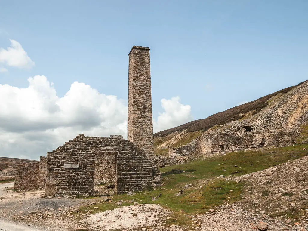
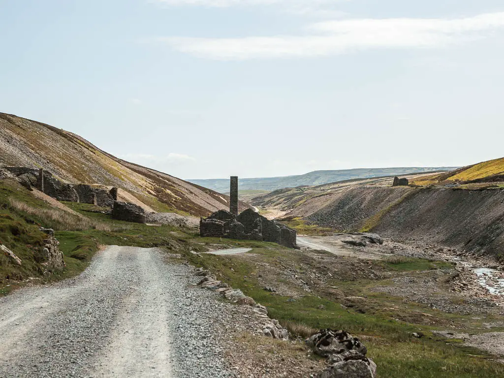
Old Gang is the ruins of a lead smelting mill, dating back to the 18th and 19th centuries. It is one of the best preserved up in the north, and is designated a Scheduled Ancient Monument. This trail runs right through it, passing by various building ruins, mine entrances, and the peat store.
If you like ruins, then you have to try this walk through Gunnerside Gill. It’s so incredibly wonderful. I have been telling everyone about this route.
What to expect on the Old Gang Smelt walk
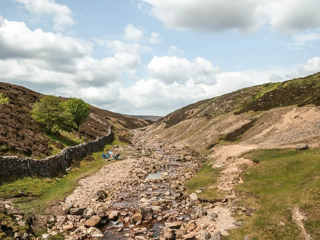
The first half of the walk, past the Old Gang Smelting Mill, I loved. Walking past the ruins, with the water of the beck flowing through the valley, and passing cute bridges.
The second half, I couldn’t wait to be over. It was so vastly bleak, with not much to look at, and just went on and on and on. Saying that, it was a sweltering hot day, with no escaping the sun pounding down on my face. This probably reduced my tolerance level a little.
This trail is actually a cycle route, and I passed more cyclists than people. I think I would have enjoyed the full circular if I was on a bike.
Is the walk hard?
The circular Old Gang Smelt walk itself is pretty easy in theory. The whole route is along this same path. There are some hills, which aren’t steep, but some are long and drawn out.
I did struggle on the second half though, which was more to do with a combination of the sun, and a never ending trail of nothingness breaking my spirits.
If I was to do this walk again, I would go as far as the Old Gang Smelting Mill, and a bit further where the path starts to circle back. I would then turn around and go back the way I came. I will show you where I mean when I describe the route below.
Is the walk dog friendly?
Dogs are allowed to walk by the Old Gang Smelting Mill, but must be kept on a lead and on the path. They are not allowed on the surrounding moorland due to ground nesting birds.

Parking to walk the Old Gang Smelt Mill trail
There is an area for parking next to surrender bridge. It’s basically a flat area of grass by the road, at the junction at the end of High road. The important thing, is it’s free.

There were a bunch of other cars here, but having now done the walk to Old Gang Smelt, this did not reflect on the trail. I think most of these people were cyclists, who also took one of the various other trails about. I only past a few other walkers around the Old Gang Smelting Mill area, then a few cyclists later on. After that, I didn’t pass a sole the rest of the way.
Other things to know
The surrounding moor is open access land, but you need to be carful if you walk on it. There are abandoned mine shafts, peat bog, and adders.
Logistics
- Start/Finish: Surrender Bridge
- Where is it: Old Gang Smelting Mill is located in the Swaledale area of the Yorkshire Dales. Post code for the area is DL11 6PR. It is near the hamlets of Kearton and Feetham (near to Reeth village).
- Public Transport: No way is a bus getting along those roads.
- Distance: 5.8 miles
- Time: 1h 40min
- Difficulty: Easy
- Terrain: Gravel trail, some road.
- Elevation: Level with undulations, and some gentle hills.
- Amenities: Nothing
- Time of year: I did the walk in late spring
Read more: Best walking routes across the Yorkshire Dales National Park
Map for the Old Gang Smelt circular walk
You can see my more detailed route map for the walk to Old Gang Smelt on Alltrails
The Old Gang Smelt Mill is very near the village of Reeth, which has a few nice walks you could try. This one along Fremington Edge gives you grand views across the Swaledale hills. Or you could try this short and easy route taking you along the river.
Route description for the Old Gang Smelting Mill Walk
First of all, getting to the start of the trail for Old Gang Smelt is something of it’s own. It’s on a road junction, and I tried out both roads, first to get in, and then to get out. Both are very narrow, and very steep. The kind where you wonder if you have gone the correct way, and seriously hope no one comes at you in the opposite direction. The route I took in, along Morley Gate and High Lane was the most precarious. It also involves having to get out of the car to open and then close a gate.
Surrender Bridge and Smelting Mill
From the car parking area, you will have a view down to Surrender Bridge one way, and the Surrender Melting Mill ruins the other.


Start the walk to Old Gang Smelt Mill
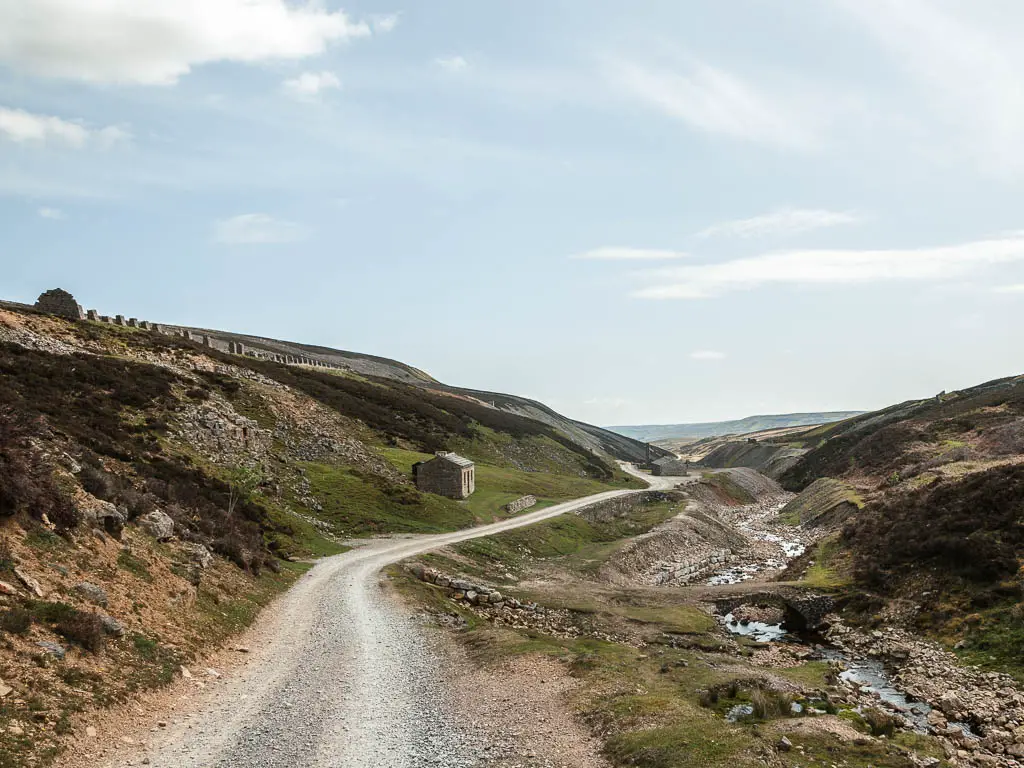
To get to the start of the trail, go and cross over the bridge, then a short way up the hill, turn left onto the gravel path.


It’s now roughly 1 mile of walking to reach the main ruins of the Old Gang Smelting Mill.
Walking around the Old Gang Smelting Mill
In the main buildings, you will find some old mining relics. I passed an older gentleman here doing some bird watching.


Some of the other buildings ruins dotted about were used for a variety of things, such as storage and offices.
This is the Old Gang mine building:

Below is one of the mine entrances, and those pillars you see up the hill are part of the Old Gang peat store. In total it can hold about 3 years supply of peat:

As you keep going, you will pass by a packhorse bridge. These are types of bridges built for horses to carry stuff over.

More bridges
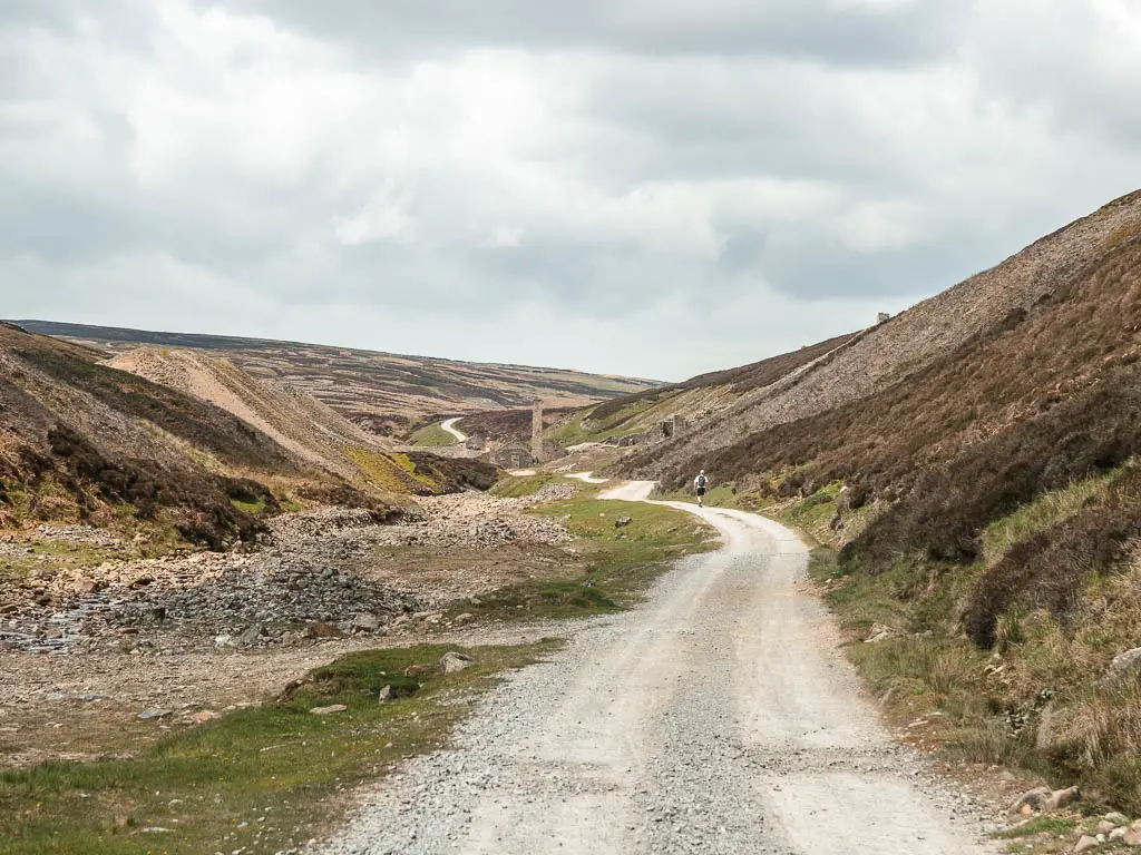
As you keep walking, past the Old Gang Smelt mill and mine buildings, you will start to make your way uphill, with another bridge ahead of you. At the junction, turn right, following the sign for Level House Bridge.


Through the gate, you will reach level house bridge, however, don’t cross over it. Instead, turn right.


You will then walk by some other ruins, mine entrances, and another bridge, all the way to reach the next gate.


Up until this point, I was really enjoying myself. The landscape was lovely, with the sound of the river flowing to my left. This is also the point where I would turn back if I was to do this walk again. As I did not turn back, I will show you what comes next…..
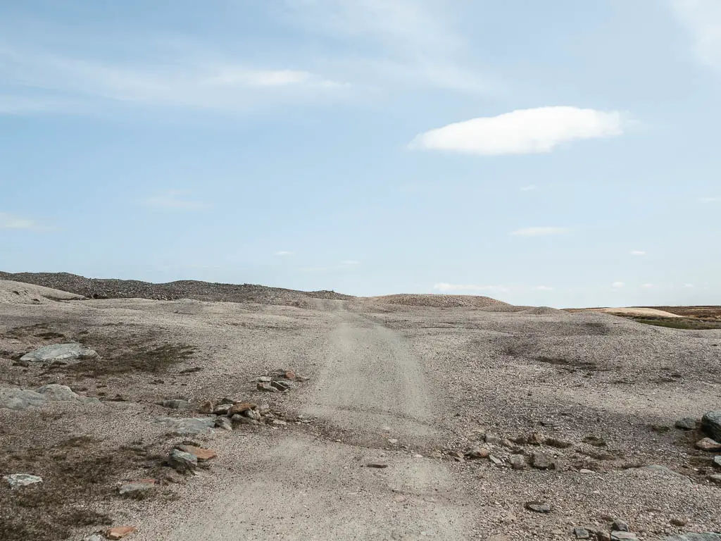
The long way back
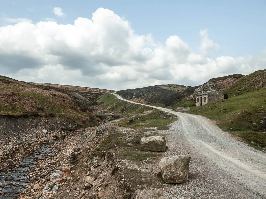
Through this gate, there is a long drawn out uphill, and it looks something like this:

I felt a little like I was in some wilderness. The sun was hitting me hard, and there was no where to hide.
Once I got over the hill and could see what was ahead, at first I was happy. Some views at last. However, my happiness soon turned to dread, as I could see the long long trail ahead into the distance as far as the eye could see, surrounded by nothing but bleakness.

There was always the hope, that once I reached that point where the trail disappears, I would have something else to look at. Even a sight of the end. But no. Another long long stretch of trail would present itself. On a positive note, it’s all downhill.
There is another lot of ruins along this bit, and some interesting bumpy hills. But they are brief. When the trail had some grass, it did provide me some variety. So that’s something.


You need to keep going, and keep going some more, all the way to the road. At the road, turn right, which will lead you back to the car park.

I can’t complain too much, as I got what I wanted. Peace and solitude.